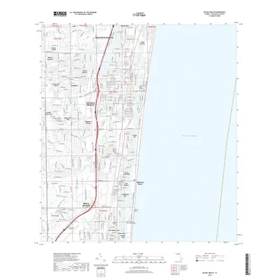
2018 Map of Delray Beach
USGS Topo · Published 2018About this map
Delray Beach and the northern reaches of Boca Raton define this coastal Florida landscape, where the Intracoastal Waterway runs parallel to the Atlantic Ocean. The map reveals a densely developed suburban and resort corridor characterized by numerous residential enclaves such as Tropic Isle, Bel-Marra, and Dunes Road. Transportation and access are anchored by I-95 and the arterial El Rio Canal, while the Calhoun Byrd Bridge and Fortieth Street Boca Raton Bridge provide essential links to the barrier island communities of Gulf Stream and Highland Beach. This modern survey documents the significant urbanization of the Gold Coast, featuring academic institutions like Everglades Univ and infrastructure such as the Boca Raton Airport. Local history is preserved at Pine Ridge Cem, set amidst sprawling neighborhoods like Sherwood Park and Franwood Pines.
Find a feature on this map
44 named features on this map. Tap any name to fly to it.
Don’t see what you’re looking for? This feature index may not catch every label — zoom into the map to look around manually.
Map Details
Editions of this 2018 Delray Beach Map
This is the sole edition of this map. No revisions or reprints were ever made.
Other maps of this area

1945 · Greenacres City
USGS Topo · 1:24,000

1945 · Lake Worth
USGS Topo · 1:24,000

1946 · West Dixie Bend
USGS Topo · 1:24,000

1946 · Boca Raton
USGS Topo · 1:24,000

1947 · Delmar Farms
USGS Topo · 1:24,000

1949 · Lake Worth
USGS Topo · 1:24,000

1949 · West Dixie Bend
USGS Topo · 1:24,000

1949 · Delmar Farms
USGS Topo · 1:24,000

1950 · Boca Raton
USGS Topo · 1:24,000

1950 · Delray Beach
USGS Topo · 1:24,000