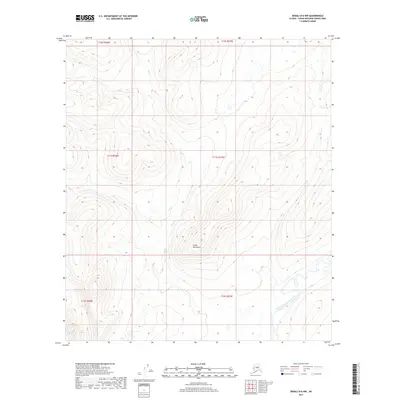
2017 Map of Denali D-6 NW
USGS Topo · Published 2017About this map
The North Fork Kuskokwim River meanders through the southeastern corner of this Alaskan interior landscape, a stark contrast to the surrounding elevations. To the north and west, the terrain rises steadily toward the Sischu Mountains, where the drainage of Lynx Cr cuts through various townships. This 2017 survey by the U.S. Geological Survey provides an intricate look at the hydrology and topography of the Unorganized Borough, documenting a vast roadless area defined by its natural watercourses and relief. The proximity of the river to the mountain slopes suggests a classic subarctic environment where seasonal runoff from the higher peaks directly feeds into the Kuskokwim watershed.
Find a feature on this map
9 named features on this map. Tap any name to fly to it.
Don’t see what you’re looking for? This feature index may not catch every label — zoom into the map to look around manually.
Map Details
Editions of this 2017 Denali D-6 NW Map
This is the sole edition of this map. No revisions or reprints were ever made.
Other maps of this area

1948 · Kantishna River
USGS Topo · 1:250,000

1950 · Medfra
USGS Topo · 1:250,000

1951 · Kantishna River
USGS Topo · 1:250,000

1951 · Ruby
USGS Topo · 1:250,000

1952 · Mount McKinley
USGS Topo · 1:250,000

1952 · Ruby A-1
USGS Topo · 1:63,360

1952 · Kantishna River
USGS Topo · 1:250,000

1952 · Kantishna River A-6
USGS Topo · 1:63,360

1952 · Ruby
USGS Topo · 1:250,000
1953 · Kantishna River A-6
USGS Topo · 1:63,360