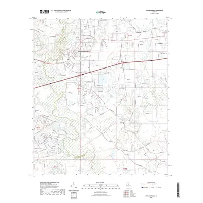
2020 Map of Denham Springs
USGS Topo · Published 2020About this map
Denham Springs serves as the focal point of this modern Louisiana survey, situated along the Amite River at the boundary between Livingston and East Baton Rouge Parish. The landscape is defined by its complex network of waterways, including the Comite River, Jones Creek, and Colyell Cr, which weave through the expanding residential corridors of Walker and Lockhart. This map captures a suburbanizing region still deeply tied to its historical landmarks, from the Palmetto Cemetery in the east to the O'Neal Cemetery on the western edge. The prominent commercial thoroughfare of Florida Blvd bisects the terrain, connecting established communities like Central and Stevensdale. This detailed study provides genealogists with essential locations for family research, such as the Hebron Cemetery, while documenting the drainage patterns of Honey Cut Bayou and Millers Canal that influence the local geography.
Find a feature on this map
31 named features on this map. Tap any name to fly to it.
Don’t see what you’re looking for? This feature index may not catch every label — zoom into the map to look around manually.
Map Details
Editions of this 2020 Denham Springs Map
This is the sole edition of this map. No revisions or reprints were ever made.
Other maps of this area

1906 · Bayou Sara
USGS Topo · 1:125,000

1908 · Baton Rouge
USGS Topo · 1:62,500

1934 · Denham Springs
USGS Topo · 1:62,500

1939 · Zachary
USGS Topo · 1:62,500

1939 · Denham Springs
USGS Topo · 1:62,500

1939 · Baton Rouge
USGS Topo · 1:62,500

1942 · Watson
USGS Topo · 1:31,680

1942 · Satsuma
USGS Topo · 1:31,680

1953 · Walker
USGS Topo · 1:24,000

1953 · St. Gabriel
USGS Topo · 1:24,000