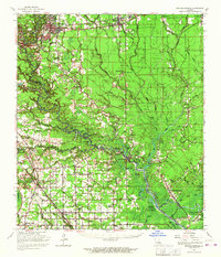
1963 Map of Denham Springs
USGS Topo · Published 1967About this map
Amite River and Bayou Manchac define the watery geography of this 1960s survey, where the lowlands of Livingston Parish meet Ascension Parish. The landscape is characterized by a dense network of waterways including Colyell Creek, Gray's Creek, and Little Lake, which supported early navigation and settlement. Distinct communities like French Settlement, Port Vincent, and Denham Springs are interconnected by both road and rail, with the Illinois Central Railroad and Louisiana & Arkansas Railway cutting through the timber and agricultural lands.
Find a feature on this map
97 named features on this map. Tap any name to fly to it.
Don’t see what you’re looking for? This feature index may not catch every label — zoom into the map to look around manually.
Map Details
Editions of this 1963 Denham Springs Map
2 editions found
Other maps of this area

1892 · Mount Airy
USGS Topo · 1:62,500

1892 · Donaldsonville
USGS Topo · 1:62,500

1906 · Bayou Sara
USGS Topo · 1:125,000

1908 · Baton Rouge
USGS Topo · 1:62,500

1934 · Denham Springs
USGS Topo · 1:62,500

1934 · Springfield
USGS Topo · 1:62,500

1935 · Gonzales
USGS Topo · 1:31,680

1936 · White Castle
USGS Topo · 1:62,500

1939 · Springfield
USGS Topo · 1:62,500

1939 · Zachary
USGS Topo · 1:62,500