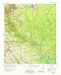
1965 Map of Denham Springs
USGS Topo · Published 1965About this map
The Amite River snakes through the heart of this mid-1960s survey, serving as a primary geographic anchor for a landscape defined by its intricate bayou network and parish boundaries. Along the northern edge, Denham Springs and Walker sit prominently along the Illinois Central railroad, while further south, the Amite River Diversion Canal represents a significant 20th-century hydrological modification. The map documents a rural society deeply connected to its waterways, featuring numerous lakeside landings and small landings such as Port Vincent and French Settlement.
Find a feature on this map
89 named features on this map. Tap any name to fly to it.
Don’t see what you’re looking for? This feature index may not catch every label — zoom into the map to look around manually.
Map Details
Editions of this 1965 Denham Springs Map
This is the sole edition of this map. No revisions or reprints were ever made.
Other maps of this area

1892 · Mount Airy
USGS Topo · 1:62,500

1892 · Donaldsonville
USGS Topo · 1:62,500

1906 · Bayou Sara
USGS Topo · 1:125,000

1908 · Baton Rouge
USGS Topo · 1:62,500

1934 · Denham Springs
USGS Topo · 1:62,500

1934 · Springfield
USGS Topo · 1:62,500

1935 · Gonzales
USGS Topo · 1:31,680

1936 · White Castle
USGS Topo · 1:62,500

1939 · Springfield
USGS Topo · 1:62,500

1939 · Zachary
USGS Topo · 1:62,500