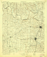
1901 Map of Denison
USGS Topo · Published 1904About this map
The Red River serves as a vital border and transit corridor on this map, separating the Chickasaw Nation of Indian Territory from the evolving settlements of North Texas. At this time, crossing the river required a network of ferries, such as Delaware Ferry and Rock Bluff Ferry, or the Colbert Bridge near the growing hub of Denison. The landscape is defined by the convergence of major rail lines, including the St. Louis and San Francisco R. R. and the Missouri Kansas and Texas R. R., which drove the development of small communities like Gordonville, Pottsboro, and Cedar Mills. Local landmarks such as Brushy Mound and an Artesian Well north of Steedman indicate the varied topography and natural resources that shaped early ranching and farming in Grayson Co. and Cooke Co.
Find a feature on this map
137 named features on this map. Tap any name to fly to it.
Don’t see what you’re looking for? This feature index may not catch every label — zoom into the map to look around manually.
Map Details
Editions of this 1901 Denison Map
4 editions found
Other maps of this area

1899 · Atoka
USGS Topo · 1:125,000

1900 · Atoka
USGS Topo · 1:125,000

1901 · Tishomingo
USGS Topo · 1:125,000

1901 · Ardmore
USGS Topo · 1:125,000

1901 · Denison
USGS Topo · 1:125,000

1902 · Gainesville
USGS Topo · 1:125,000

1918 · Ardmore
USGS Topo · 1:125,000

1943 · Gainesville
USGS Topo · 1:125,000

1954 · Sherman
USGS Topo · 1:250,000

1957 · Denison Dam
USGS Topo · 1:24,000