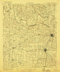
1901 Map of Denison
USGS Topo · Published 1921About this map
The Red River serves as a complex borderland on this turn-of-the-century survey, dividing the Chickasaw Nation in Indian Territory from North Texas. This era of transition is marked by a landscape tied to the water, where transit depends on a series of historic river crossings including Delaware Ferry, Stillhouse Ferry, and the Colbert Bridge. The convergence of major rail lines like the Missouri Kansas and Texas R. R. and the Texas and Pacific R. R. at Denison highlights the city's role as a vital transportation gateway during the regional expansion.
Find a feature on this map
127 named features on this map. Tap any name to fly to it.
Don’t see what you’re looking for? This feature index may not catch every label — zoom into the map to look around manually.
Map Details
Editions of this 1901 Denison Map
4 editions found
Other maps of this area

1899 · Atoka
USGS Topo · 1:125,000

1900 · Atoka
USGS Topo · 1:125,000

1901 · Tishomingo
USGS Topo · 1:125,000

1901 · Ardmore
USGS Topo · 1:125,000

1901 · Denison
USGS Topo · 1:125,000

1902 · Gainesville
USGS Topo · 1:125,000

1918 · Ardmore
USGS Topo · 1:125,000

1943 · Gainesville
USGS Topo · 1:125,000

1954 · Sherman
USGS Topo · 1:250,000

1957 · Denison Dam
USGS Topo · 1:24,000