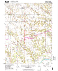
1998 Map of Dennison
USGS Topo · Published 2002About this map
Dennison and the nearby hamlet of McKeen anchor this prairie and woodland landscape along the Illinois and Indiana border. The terrain is defined by a dense network of drainage, including Hawks Creek and Sugar Creek, which carve through the Elbridge and Wabash townships. This 1990s representation of the area preserves the locations of several essential community institutions from earlier generations, such as the Armstrong Sch and multiple rural houses of worship like Dunlap Ch. Cultural landmarks including Camp Illiana near Wanda Lake and the Roadside Park near Weaver sit alongside industrial features like the Conrail line and scattered Oil Wells. To the southeast, the landscape opens into the Prairieton region where the Wabash River meets Chestnut Bayou, marking the transition from upland creek valleys to broader river bottomlands.
Find a feature on this map
44 named features on this map. Tap any name to fly to it.
Don’t see what you’re looking for? This feature index may not catch every label — zoom into the map to look around manually.
Map Details
Editions of this 1998 Dennison Map
This is the sole edition of this map. No revisions or reprints were ever made.
Other maps of this area

1932 · Marshall
USGS Topo · 1:62,500

1937 · Marshall
USGS Topo · 1:62,500

1940 · Pimento
USGS Topo · 1:24,000

1941 · Terre Haute
USGS Topo · 1:24,000

1942 · Hutton
USGS Topo · 1:24,000

1942 · Dennison
USGS Topo · 1:24,000

1947 · Paris
USGS Topo · 1:62,500

1948 · Terre Haute
USGS Topo · 1:24,000

1949 · Paris
USGS Topo · 1:62,500

1950 · New Goshen
USGS Topo · 1:24,000