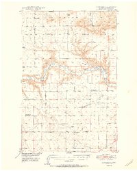
1950 Map of Dent Bridge
USGS Topo · Published 1950About this map
The Teton River cuts a deep, meandering course through this part of Chouteau County, serving as the primary geographic anchor for a landscape defined by expansive coulees and high plains. The map records a rural infrastructure in transition during the late 1940s, notably marked by several education sites such as Genou School and the Promised Land School No 2. A distinct shift in settlement patterns is visible where The School House (Abandoned) and Antelope School (Abandoned) appear as vestiges of earlier homesteading eras. Transportation in the region is defined by the namesake Dent Bridge and the evocative Bootlegger Trail which runs along the western edge. Notable water features like Antelope Lake and Weatherwax punctuate the arid terrain, while scattered human footprints are found at a Gravel Pit, a Windmill, and a lone Corral.
Find a feature on this map
30 named features on this map. Tap any name to fly to it.
Don’t see what you’re looking for? This feature index may not catch every label — zoom into the map to look around manually.
Map Details
Editions of this 1950 Dent Bridge Map
3 editions found
Other maps of this area

1886 · Great Falls
USGS Topo · 1:250,000

1890 · Fort Benton
USGS Topo · 1:250,000

1892 · Fort Benton
USGS Topo · 1:250,000

1897 · Fort Benton
USGS Topo · 1:250,000

1948 · Portage
USGS Topo · 1:62,500

1949 · Portage
USGS Topo · 1:62,500

1949 · Timber Coulee
USGS Topo · 1:62,500

1949 · Great Falls
USGS Topo · 1:62,500

1950 · Timber Coulee
USGS Topo · 1:62,500

1950 · Dent Bridge
USGS Topo · 1:62,500