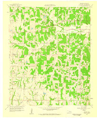
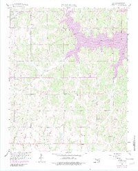
1958 Map of Denver
USGS Topo · Published 1959About this map
Denver and the surrounding township of Noble in Cleveland County are captured here at the close of the 1950s, showing a landscape defined by small-scale agriculture and early petroleum extraction. The settlement of Maguire sits in the southern portion of the quadrangle, while the rural interior is punctuated by an extensive network of schoolhouses, including Adair Sch, Falls Sch, and Enterprise Sch, reflecting the community structure of the era. The Old Indian Boundary cuts through the territory, a significant cadastral line that historically separated tribal lands.
Find a feature on this map
27 named features on this map. Tap any name to fly to it.
Don’t see what you’re looking for? This feature index may not catch every label — zoom into the map to look around manually.
Map Details
Editions of this 1958 Denver Map
5 editions found
Other maps of this area

1892 · Moore
USGS Topo · 1:62,500

1893 · Norman
USGS Topo · 1:62,500

1898 · Purcell
USGS Topo · 1:125,000

1910 · McComb
USGS Topo · 1:62,500

1925 · Norman NO 2
USGS Topo · 1:24,000

1930 · McLoud
USGS Topo · 1:62,500

1934 · Moore
USGS Topo · 1:62,500

1936 · Norman
USGS Topo · 1:62,500

1938 · Moore
USGS Topo · 1:62,500

1954 · Oklahoma City
USGS Topo · 1:250,000