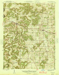
1946 Map of Depauw
USGS Topo · Published 1946About this map
The Southern railroad corridor serves as the primary industrial axis for this portion of Harrison County in the mid-1940s, connecting the settlements of Depauw and Ramsey. The landscape is defined by the winding course of the Blue River along the western boundary, where the terrain breaks into the steep elevations of Devils Hollow. Away from the river, the map reveals a well-distributed network of rural social centers including Mt Tabor Ch and Hall Chapel, alongside essential local institutions like the Depauw Sch and Brushy Valley Sch. Genealogy researchers will find several family-named landmarks such as Smith Cem and Pitman Cem, which anchor the small farming communities of Frenchtown, Moberly, and Pennington within the townships of Spencer and Morgan.
Find a feature on this map
24 named features on this map. Tap any name to fly to it.
Don’t see what you’re looking for? This feature index may not catch every label — zoom into the map to look around manually.
Map Details
Editions of this 1946 Depauw Map
2 editions found
Other maps of this area

1931 · Corydon
USGS Topo · 1:62,500

1944 · Corydon West
USGS Topo · 1:24,000

1946 · Leavenworth
USGS Topo · 1:24,000

1946 · Depauw
USGS Topo · 1:24,000

1947 · Leavenworth
USGS Topo · 1:24,000

1947 · Corydon West
USGS Topo · 1:24,000

1947 · Hardinsburg
USGS Topo · 1:24,000

1948 · Corydon East
USGS Topo · 1:24,000

1948 · Milltown
USGS Topo · 1:24,000

1949 · Hardinsburg
USGS Topo · 1:24,000