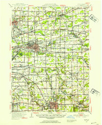
1948 Map of Depew
USGS Topo · Published 1953About this map
Buffalo Municipal Airport and the surrounding suburban expansion define this mid-century landscape east of Buffalo. The map reveals an area undergoing a transition from traditional rural hamlets like Williston and Marilla to more developed industrial and institutional corridors. Major transportation arteries, including Genesee Street and the Erie Railroad, cut across the terrain, linking various centers of activity. Institutional presence is heavy in the northeast, where the County Penitentiary and County Home and Infirmary are situated near Wende. For genealogists and local historians, the sheet offers a census of the era's civic infrastructure, from the dozens of numbered country schools such as School No 10 to family landmarks like Cole Cem and the unique Pine Rest Pet Cem. The hydrology is equally detailed, tracing the winding paths of Cazenovia Creek and Cayuga Creek through the varied townships.
Find a feature on this map
109 named features on this map. Tap any name to fly to it.
Don’t see what you’re looking for? This feature index may not catch every label — zoom into the map to look around manually.
Map Details
Editions of this 1948 Depew Map
3 editions found

Other maps of this area

1894 · Buffalo
USGS Topo · 1:62,500

1897 · Tonawanda
USGS Topo · 1:62,500

1897 · Medina
USGS Topo · 1:62,500

1897 · Lockport
USGS Topo · 1:62,500

1899 · Niagara
USGS Topo · 1:125,000

1900 · Tonawanda
USGS Topo · 1:62,500

1901 · Buffalo
USGS Topo · 1:62,500

1901 · Tonawanda
USGS Topo · 1:62,500

1902 · Lockport
USGS Topo · 1:62,500

1905 · Attica
USGS Topo · 1:62,500