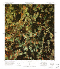
1978 Map of Derby Line Port of Entry
USGS Topo · Published 1978About this map
The international border between Vermont and Quebec defines the landscape of this 1970s color image map, highlighting the unique layout of the divided border towns. The contiguous settlements of Stanstead and Rock Island in Canada meet Derby Line in the United States, creating a rare shared urban fabric where the boundary crosses through streets and buildings. The 1975 aerial photography used to create this sheet captures a bird's-eye view of the mixed agricultural and forested terrain, punctuated by the industrial presence of Judge Mills along the Tomifobia River. To the south, the terrain rises toward Nelson Hill and Bates Hill, with the waters of Crystal Lake and Crystal Brook flowing through the valley. Local roads such as Smith Road and Stearns Road provide a detailed look at the rural property patterns and small communities like Tice and Holland that surround this major port of entry.
Find a feature on this map
25 named features on this map. Tap any name to fly to it.
Don’t see what you’re looking for? This feature index may not catch every label — zoom into the map to look around manually.
Map Details
Editions of this 1978 Derby Line Port of Entry Map
This is the sole edition of this map. No revisions or reprints were ever made.
Other maps of this area

1919 · Lake Memphremagog
USGS Topo · 1:62,500

1920 · Derby
USGS Topo · 1:62,500

1923 · Lake Memphremagog
USGS Topo · 1:48,000

1924 · Island Pond
USGS Topo · 1:48,000

1925 · Memphremagog
USGS Topo · 1:62,500

1926 · Island Pond
USGS Topo · 1:62,500

1949 · Jackman
USGS Topo · 1:250,000

1950 · Lake Champlain
USGS Topo · 1:250,000

1950 · Lewiston
USGS Topo · 1:250,000

1953 · Island Pond
USGS Topo · 1:62,500