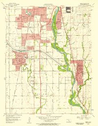
1956 Map of Derby
USGS Topo · Published 1957About this map
The Arkansas River corridor south of Wichita reveals a landscape of mid-century suburban expansion and aviation infrastructure. In the northeast, the massive Mc Connell Air Force Base dominates the terrain, while the newly constructed Kansas Turnpike bisects the region, bypassing older rail lines like the Chicago Rock Island and Pacific. Small communities such as Haysville and Derby are shown at a pivotal moment of growth, supported by numerous neighborhood institutions like St Marys Sch and Riverview Sch. Local leisure is represented by the Drive-in Theater and Meadow Lake, while agricultural remnants like Sand Burr Hill and the complex drainage of the Cowskin Floodway persist despite the encroaching residential developments of Oaklawn and Sunset Park.
Find a feature on this map
38 named features on this map. Tap any name to fly to it.
Don’t see what you’re looking for? This feature index may not catch every label — zoom into the map to look around manually.
Map Details
Editions of this 1956 Derby Map
This is the sole edition of this map. No revisions or reprints were ever made.
Other maps of this area

1889 · Wichita
USGS Topo · 1:125,000

1890 · Wellington
USGS Topo · 1:125,000

1894 · Wichita
USGS Topo · 1:125,000

1943 · Wichita West
USGS Topo · 1:31,680

1943 · Wichita East
USGS Topo · 1:31,680

1943 · Derby
USGS Topo · 1:31,680

1943 · Bayneville
USGS Topo · 1:31,680

1945 · Andover
USGS Topo · 1:31,680

1950 · Bayneville
USGS Topo · 1:24,000

1955 · Belle Plaine
USGS Topo · 1:24,000