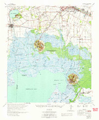
1966 Map of Derouen
USGS Topo · Published 1966About this map
New Iberia anchor this mid-1960s coastal survey, revealing a landscape defined by the sugar and oil industries of South Louisiana. The map details the region's famous salt domes, including Avery Island and Weeks Island, which rise distinctly above the surrounding marshlands of Weeks Bay and Vermilion Bay. These high grounds are centerpieces of industrial activity, marked by the Avery Island Oil Field and the Weeks Island Oil and Gas Field.
Find a feature on this map
100 named features on this map. Tap any name to fly to it.
Don’t see what you’re looking for? This feature index may not catch every label — zoom into the map to look around manually.
Map Details
Editions of this 1966 Derouen Map
This is the sole edition of this map. No revisions or reprints were ever made.
Other maps of this area

1932 · Abbeville SE
USGS Topo · 1:31,680

1932 · Abbeville NE
USGS Topo · 1:31,680

1937 · Bayou Sale
USGS Topo · 1:62,500

1937 · Jeanerette
USGS Topo · 1:62,500

1937 · Derouen
USGS Topo · 1:62,500

1939 · St. Martinsville
USGS Topo · 1:62,500

1941 · Loreauville
USGS Topo · 1:62,500

1945 · New Orleans
USGS Topo · 1:250,000

1946 · Milton
USGS Topo · 1:31,680

1946 · Redfish Point NE
USGS Topo · 1:31,680