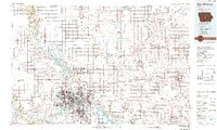
1984 Map of Des Moines
USGS Topo · Published 1992About this map
Des Moines and its suburban expansion define the landscape in this mid-1980s snapshot, where the confluence of the Des Moines River and the Raccoon River anchors the capital city's geography. The map reveals the recently matured reservoir system, dominated by Saylorville Lake and Big Creek Lake, which fundamentally altered the drainage patterns of the region's northern reaches. Further north, the academic footprint of Ames is anchored by Iowa State University, while institutional sites like the Woodward State Hospital and the sprawling Camp Dodge Military Reservation reflect the area's role as a center for government and state services.
Find a feature on this map
191 named features on this map. Tap any name to fly to it.
Don’t see what you’re looking for? This feature index may not catch every label — zoom into the map to look around manually.
Map Details
Editions of this 1984 Des Moines Map
2 editions found
Other maps of this area

1905 · Des Moines
USGS Topo · 1:62,500

1907 · Des Moines
USGS Topo · 1:62,500

1908 · Waukee
USGS Topo · 1:62,500

1909 · Knoxville
USGS Topo · 1:62,500

1910 · Milo
USGS Topo · 1:62,500

1910 · Pella
USGS Topo · 1:62,500

1911 · Madrid
USGS Topo · 1:62,500

1911 · Slater
USGS Topo · 1:62,500

1912 · Knoxville
USGS Topo · 1:62,500

1912 · Pella
USGS Topo · 1:62,500