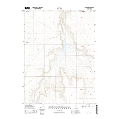
2014 Map of Desert Ranch
USGS Topo · Published 2014About this map
Desert Ranch sits at the heart of this high-desert drainage system in Elko County, where the management of seasonal water defines the landscape. The centerpiece of this ranching geography is the Desert Ranch Reservoir, which captures the flow of Fourmile Cr as it descends from the surrounding elevations. To the west, the Monument Hills overlook the broad expanse of Twelvemile Flat, a dry basin typical of the Great Basin's topography. The map detail highlights the reliance on creek systems like Chimney Cr to sustain livestock and land use in this arid environment. This 2014 survey captures the persistence of the American ranching tradition, showing how topographic features and modern boundaries intersect in the remote interior of Nevada.
Find a feature on this map
11 named features on this map. Tap any name to fly to it.
Don’t see what you’re looking for? This feature index may not catch every label — zoom into the map to look around manually.
Map Details
Editions of this 2014 Desert Ranch Map
This is the sole edition of this map. No revisions or reprints were ever made.
Other maps of this area

1955 · McDermitt
USGS Topo · 1:250,000

1959 · McDermitt
USGS Topo · 1:250,000

1964 · Hat Peak
USGS Topo · 1:62,500

1964 · Wilson Reservoir
USGS Topo · 1:62,500

1973 · Twelvemile Flat
USGS Topo · 1:24,000
1974 · Twelvemile Flat SE
USGS Topo · 1:24,000

1974 · Middle Draw Reservoir
USGS Topo · 1:24,000

1974 · Winters Ranch Reservoir
USGS Topo · 1:24,000

1974 · Desert Ranch
USGS Topo · 1:24,000
1977 · Silver Lake
USGS Topo · 1:24,000