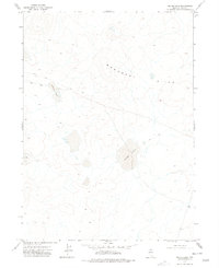
1977 Map of Silver Lake
USGS Topo · Published 1977About this map
Silver Lake and Shallow Lake define this high-desert basin in northern Nevada, where seasonal water catchment shapes the arid landscape. The terrain is dominated by the Monument Hills, a prominent upland formation that rises above the surrounding flats. During this era of the late 1970s, the area remained largely undeveloped, characterized by a network of primitive Jeep Trails that provided the only access through the remote Elko County interior. The map illustrates a classic Great Basin topographic pattern, where isolated lake beds act as focal points for local drainage systems in an otherwise dry and expansive environment.
Find a feature on this map
4 named features on this map. Tap any name to fly to it.
Don’t see what you’re looking for? This feature index may not catch every label — zoom into the map to look around manually.
Map Details
Editions of this 1977 Silver Lake Map
This is the sole edition of this map. No revisions or reprints were ever made.
Other maps of this area

1955 · McDermitt
USGS Topo · 1:250,000

1959 · McDermitt
USGS Topo · 1:250,000

1973 · McCleary Wells
USGS Topo · 1:24,000

1973 · Corral Lake
USGS Topo · 1:24,000

1973 · Twelvemile Flat
USGS Topo · 1:24,000
1973 · Star Valley Ridge SE
USGS Topo · 1:24,000
1974 · Twelvemile Flat SE
USGS Topo · 1:24,000

1974 · Middle Draw Reservoir
USGS Topo · 1:24,000

1974 · Winters Ranch Reservoir
USGS Topo · 1:24,000

1974 · Desert Ranch
USGS Topo · 1:24,000