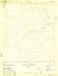
1948 Map of Desert SW
USGS Topo · Published 1948About this map
Tularosa Valley dominates this arid landscape at the edge of the New Mexico-Texas border. The map captures a quiet, utilitarian expanse of the high desert during the late 1940s, where survival was tied to scattered water sources like the Pit Tank and Windmill. This survey was compiled from aerial photography by the Army Air Force and field edited in 1947, revealing the infrastructure of the Fort Bliss Military Reservation in the northwestern corner. The McCracken Ranch serves as a primary marker of human habitation in a region otherwise defined by terrain features such as Davis Dome and the remnants of an Abandoned Well. The presence of the Southern Pacific railroad line cutting through the north highlights the vital transportation corridor connecting these remote desert reaches to the broader American West.
Find a feature on this map
10 named features on this map. Tap any name to fly to it.
Don’t see what you’re looking for? This feature index may not catch every label — zoom into the map to look around manually.
Map Details
Editions of this 1948 Desert SW Map
This is the sole edition of this map. No revisions or reprints were ever made.
Other maps of this area

1896 · El Paso
USGS Topo · 1:125,000

1908 · El Paso
USGS Topo · 1:125,000

1939 · Heuco Tanks
USGS Topo · 1:62,500

1940 · Heuco Tanks
USGS Topo · 1:62,500

1940 · Newman
USGS Topo · 1:62,500

1941 · Desert
USGS Topo · 1:62,500

1942 · Fort Bliss
USGS Topo · 1:62,500

1943 · Desert
USGS Topo · 1:62,500

1943 · Newman
USGS Topo · 1:62,500

1944 · Heuco Tanks
USGS Topo · 1:62,500