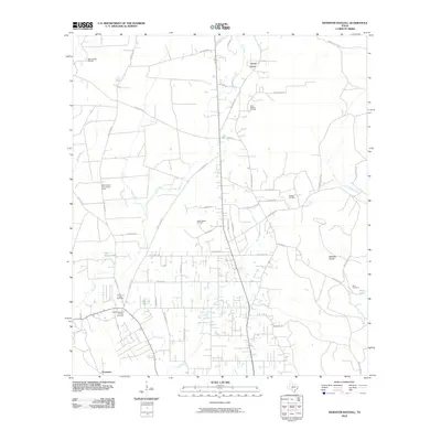
2010 Map of Deserter Baygall
USGS Topo · Published 2010About this map
Beech Creek Oil Field and the surrounding energy-producing landscape define this portion of Hardin County, Texas, at the end of the first decade of the 21st century. The terrain is a complex network of industrial extraction and local settlements, where the South Hampton Oil and Gas Field and several divisions of the Silsbee Oil Field intersect with rural communities. The map highlights key landmarks for local history and genealogy, including the Hooks Cravey Cemetery near Fresenius and Gore Cemetery situated near Gore Lake. This area north of Silsbee is marked by its numerous roads such as Gore Store Rd and Old Kountze Rd, which provide access to timber and mineral resources. Natural features like Mill Creek and Dry Creek snake through the landscape, alongside the Smart School Fire Lookout Tower, reflecting a region balancing forestry management with a robust petroleum economy.
Find a feature on this map
52 named features on this map. Tap any name to fly to it.
Don’t see what you’re looking for? This feature index may not catch every label — zoom into the map to look around manually.
Map Details
Editions of this 2010 Deserter Baygall Map
This is the sole edition of this map. No revisions or reprints were ever made.
Other maps of this area

1954 · Beaumont
USGS Topo · 1:250,000

1955 · Silsbee
USGS Topo · 1:62,500

1955 · Kountze
USGS Topo · 1:62,500

1957 · Beaumont
USGS Topo · 1:250,000

1958 · Warren
USGS Topo · 1:62,500

1958 · Spurger
USGS Topo · 1:62,500

1984 · Beaumont
USGS Topo · 1:250,000

1984 · Potato Patch Lake
USGS Topo · 1:24,000
1984 · Silsbee
USGS Topo · 1:24,000
1984 · Kountze South
USGS Topo · 1:24,000