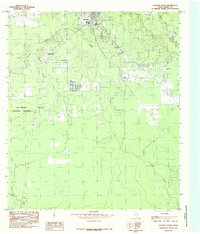
1984 Map of Kountze South
USGS Topo · Published 1985About this map
The settlement of Old Hardin stands as a focal point in this portion of the Texas Piney Woods, situated just south of the county seat at Kountze. This mid-1980s survey captures a landscape defined by the intersection of conservation and industry, where the Big Thicket National Preserve protects the diverse ecology of the region alongside active Oil Field operations. The drainage network is particularly dense here, with Cypress Creek and Village Creek carving through the terrain, while Bear Grass Ridge provides a subtle topographic variation in the northeast. Smaller locales like Nona and Little Rock are documented along the established transport corridors, reflecting the enduring rural character of Hardin County during this era. The map provides a look at the transition from wild wetlands and preserve land to the industrial extraction sites that have long supported the local economy.
Find a feature on this map
14 named features on this map. Tap any name to fly to it.
Don’t see what you’re looking for? This feature index may not catch every label — zoom into the map to look around manually.
Map Details
Editions of this 1984 Kountze South Map
This is the sole edition of this map. No revisions or reprints were ever made.
Other maps of this area

1932 · Beaumont
USGS Topo · 1:62,500

1954 · Beaumont
USGS Topo · 1:250,000

1955 · Silsbee
USGS Topo · 1:62,500

1955 · Kountze
USGS Topo · 1:62,500

1955 · Sour Lake
USGS Topo · 1:62,500

1957 · Beaumont
USGS Topo · 1:250,000
1960 · Voth
USGS Topo · 1:24,000

1984 · Beaumont
USGS Topo · 1:250,000

1984 · Sour Lake
USGS Topo · 1:24,000
1984 · Bevil Oaks
USGS Topo · 1:24,000