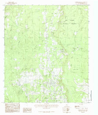
1984 Map of Deserter Baygall
USGS Topo · Published 1985About this map
Big Thicket National Preserve dominates the eastern landscape of this Hardin County area, protecting a complex network of wetlands and dense woodlands. The terrain is defined by the slow movement of water through features like Deserter Baygall and Deserter Island, illustrating the distinctive biological and hydrological character of the region. Local watercourses including Boggy Creek, Mill Creek, and the seasonally variable Dry Creek snake through the low-lying topography. The map reveals the intricate drainage patterns of the Texas Gulf Coastal Plain, where narrow corridors like Jack Gore and Baygall Gore feed into larger sloughs. While mostly comprised of natural bottomlands, the presence of a lone Cem and scattered structures near Caney Head mark the sparse human footprint within this protected wilderness during the late 1970s and early 1980s.
Find a feature on this map
17 named features on this map. Tap any name to fly to it.
Don’t see what you’re looking for? This feature index may not catch every label — zoom into the map to look around manually.
Map Details
Editions of this 1984 Deserter Baygall Map
This is the sole edition of this map. No revisions or reprints were ever made.
Other maps of this area

1954 · Beaumont
USGS Topo · 1:250,000

1955 · Silsbee
USGS Topo · 1:62,500

1955 · Kountze
USGS Topo · 1:62,500

1957 · Beaumont
USGS Topo · 1:250,000

1958 · Warren
USGS Topo · 1:62,500

1958 · Spurger
USGS Topo · 1:62,500

1984 · Beaumont
USGS Topo · 1:250,000

1984 · Potato Patch Lake
USGS Topo · 1:24,000
1984 · Silsbee
USGS Topo · 1:24,000
1984 · Kountze South
USGS Topo · 1:24,000