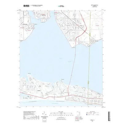
2021 Map of Destin
USGS Topo · Published 2021About this map
The coastal geometry of the Florida Panhandle is meticulously charted here, defined by the narrow peninsula of Destin separating the Gulf of Mexico from the expansive Choctawhatchee Bay. North of the bay, the twin cities of Niceville and Valparaiso wrap around Boggy Bayou, where a network of residential streets and water-dependent landings characterizes the shoreline. The map documents the intricate waterways and points that define this maritime landscape, from Moreno Point near the Destin Executive Airport to the quieter reaches of Villa Tasso and Seminole. Inland, the terrain is marked by coastal lakes such as Puddin Head Lake and Grass Lake, while the Intracoastal Waterway cuts through the bay, serving as a vital artery for regional transit. This 2021 survey provides a clear view of modern development and infrastructure along the Okaloosa and Walton county line.
Find a feature on this map
158 named features on this map. Tap any name to fly to it.
Don’t see what you’re looking for? This feature index may not catch every label — zoom into the map to look around manually.
Map Details
Editions of this 2021 Destin Map
This is the sole edition of this map. No revisions or reprints were ever made.
Other maps of this area

1934 · Holt
USGS Topo · 1:48,000

1934 · Niceville
USGS Topo · 1:48,000

1935 · Villa Tasso
USGS Topo · 1:48,000

1936 · Niceville
USGS Topo · 1:62,500

1937 · Holt
USGS Topo · 1:62,500

1938 · Mary Esther
USGS Topo · 1:62,500

1938 · Villa Tasso
USGS Topo · 1:62,500

1956 · Niceville
USGS Topo · 1:62,500

1956 · Fort Walton Beach
USGS Topo · 1:62,500

1956 · Holt
USGS Topo · 1:62,500