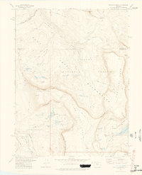
1977 Map of Devils Causeway
USGS Topo · Published 1978About this map
Chinese Wall and the narrow ridge of Devils Causeway dominate this high-altitude landscape along the border of Rio Blanco and Garfield counties. Surveyed in the mid-1970s, the map detail focuses on the alpine terrain of the Flat Tops Wilderness, where the Routt National Forest meets the White River National Forest. The hydrology of the area is captured through a dense network of mountain lakes, including the cluster of West Lost Lake and East Lost Lake, alongside the larger Stillwater Reservoir to the southeast. These waters feed prominent drainages such as the East Fork Williams Fork and the North Fork White River. The presence of numerous pack trails and remote passes like Mandall Pass underscores the region's character as a roadless wilderness managed for conservation and backcountry recreation shortly after its formal designation.
Find a feature on this map
45 named features on this map. Tap any name to fly to it.
Don’t see what you’re looking for? This feature index may not catch every label — zoom into the map to look around manually.
Map Details
Editions of this 1977 Devils Causeway Map
4 editions found
Other maps of this area

1927 · Glenwood Springs
USGS Topo · 1:125,000

1930 · Glenwood Springs
USGS Topo · 1:125,000

1954 · Craig
USGS Topo · 1:250,000

1957 · Craig
USGS Topo · 1:250,000

1957 · Leadville
USGS Topo · 1:250,000

1958 · Craig
USGS Topo · 1:250,000

1959 · Leadville
USGS Topo · 1:250,000

1960 · Leadville
USGS Topo · 1:250,000

1960 · Craig
USGS Topo · 1:250,000

1962 · Leadville
USGS Topo · 1:250,000