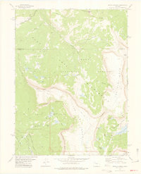
1977 Map of Devils Causeway
USGS Topo · Published 1978About this map
Devils Causeway anchors this high-elevation landscape, where the Flat Tops Wilderness straddles the line between Rio Blanco and Garfield counties. The topography is defined by the massive basalt plateau of The Flat Tops and the dramatic escarpment of the Chinese Wall. Numerous alpine basins hold clusters of water bodies including Skinny Fish Lake, McGinnis Lake, and the Lost Lakes Peaks group. This 1970s survey documents a strictly non-motorized landscape, where access is dictated by the Blue Mountain Trail and various unnamed pack routes. The hydrology is dominated by the headwaters of the East Fork and West Fork Williams Fork flowing north, while the Stillwater Reservoir and North Fork White River collect drainage to the south, illustrating the complex watershed divide at Mandall Pass.
Find a feature on this map
41 named features on this map. Tap any name to fly to it.
Don’t see what you’re looking for? This feature index may not catch every label — zoom into the map to look around manually.
Map Details
Editions of this 1977 Devils Causeway Map
4 editions found
Other maps of this area

1927 · Glenwood Springs
USGS Topo · 1:125,000

1930 · Glenwood Springs
USGS Topo · 1:125,000

1954 · Craig
USGS Topo · 1:250,000

1957 · Craig
USGS Topo · 1:250,000

1957 · Leadville
USGS Topo · 1:250,000

1958 · Craig
USGS Topo · 1:250,000

1959 · Leadville
USGS Topo · 1:250,000

1960 · Leadville
USGS Topo · 1:250,000

1960 · Craig
USGS Topo · 1:250,000

1962 · Leadville
USGS Topo · 1:250,000