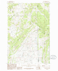
1986 Map of Devils Fence
USGS Topo · Published 1986About this map
Helena National Forest and Deerlodge National Forest meet in this 1980s landscape, where the Jefferson and Broadwater county lines intersect near the prominent summit of Devils Fence. The topography is characterized by a dense network of gulches and water sources, suggesting an environment where water management was critical for the local economy. Evidence of mineral exploration and historical extractive industry is widespread across the terrain, notably near Frenchman Hill and throughout the southern reaches of the quadrangle. Small-scale resource extraction is indicated by scattered Mine Shaft locations and numerous unnamed Prospects. High-elevation springs such as Rogers Spring, Hope Spring, and Spears Gulch Spring provide the headwaters for drainages like Sand Creek and Slim Sam Creek, forming a complex drainage pattern that has likely guided travel and land use through these forest lands for generations.
Find a feature on this map
33 named features on this map. Tap any name to fly to it.
Don’t see what you’re looking for? This feature index may not catch every label — zoom into the map to look around manually.
Map Details
Editions of this 1986 Devils Fence Map
This is the sole edition of this map. No revisions or reprints were ever made.
Other maps of this area

1886 · Fort Logan
USGS Topo · 1:250,000

1948 · White Sulphur Springs
USGS Topo · 1:250,000

1949 · Radersburg
USGS Topo · 1:62,500

1950 · Devils Fence
USGS Topo · 1:62,500

1950 · Townsend
USGS Topo · 1:62,500

1950 · Clancy
USGS Topo · 1:62,500

1958 · White Sulphur Springs
USGS Topo · 1:250,000

1961 · White Sulphur Springs
USGS Topo · 1:250,000

1965 · White Sulphur Springs
USGS Topo · 1:250,000

1976 · Townsend
USGS Topo · 1:100,000