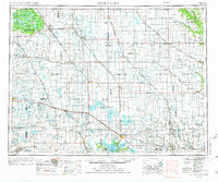
1953 Map of Devils Lake
USGS Topo · Published 1974About this map
The Turtle Mountain Indian Reservation anchors the northwestern corner of this landscape, characterized by the dense clustering of water bodies like Carpenter Lake and Jarvis Lake along the international border. This era in North Dakota shows a mature agricultural and transit network, where the Burlington Northern railroad links established grain-handling hubs including Osnabrock, Langdon, and Rolla. The map reveals a significant focus on conservation and public lands, with extensive tracts dedicated to the Lake Alice National Wildlife Refuge and the Silver Lake National Wildlife Refuge. Further south, the complex shoreline of Devils Lake is meticulously documented, featuring Creel Bay and Mission Bay adjacent to the Fort Totten Indian Reservation. Rural community life is marked by local landmarks such as the Rose Hill School and various grain elevators that define the small-town skylines of Nekoma and Fairdale.
Find a feature on this map
166 named features on this map. Tap any name to fly to it.
Don’t see what you’re looking for? This feature index may not catch every label — zoom into the map to look around manually.
Map Details
Editions of this 1953 Devils Lake Map
3 editions found

Other maps of this area

1918 · Walhalla
USGS Topo · 1:62,500

1928 · Tokio
USGS Topo · 1:62,500

1930 · Pekin
USGS Topo · 1:62,500

1930 · Hamar
USGS Topo · 1:62,500

1931 · Oberon
USGS Topo · 1:62,500

1931 · Tokio
USGS Topo · 1:62,500

1931 · Devils Lake
USGS Topo · 1:62,500

1932 · Flora
USGS Topo · 1:62,500

1932 · Grahams Island
USGS Topo · 1:62,500

1935 · Dunseith
USGS Topo · 1:48,000