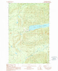
1989 Map of Devils Slide
USGS Topo · Published 1989About this map
The South Fork Tolt Reservoir dominates this portion of the Snoqualmie National Forest, serving as a critical infrastructure point within the Watershed Boundary (City of Seattle). This 1980s provisional survey illustrates a landscape defined by hydraulic engineering and forest management, where Intake Towers and a Gaging Station monitor the water supply. The terrain rises sharply toward landmarks such as the Devils Slide and the Cascade 3702 Lookout Tower, while the southern reaches are drained by the North Fork Snoqualmie River. Smaller water bodies like Lynch Lake, Black Lake, and the uniquely named Lake Titicaca dot the high elevations. For the researcher, the map preserves the exact locations of service infrastructure like Wagner Bridge and numerous resource extraction sites including quarries and borrow pits that supported the development of this protected watershed.
Find a feature on this map
28 named features on this map. Tap any name to fly to it.
Don’t see what you’re looking for? This feature index may not catch every label — zoom into the map to look around manually.
Map Details
Editions of this 1989 Devils Slide Map
This is the sole edition of this map. No revisions or reprints were ever made.
Other maps of this area

1921 · Sultan
USGS Topo · 1:125,000

1923 · Sultan
USGS Topo · 1:125,000

1953 · Snoqualmie
USGS Topo · 1:24,000

1953 · Sultan
USGS Topo · 1:24,000

1953 · Lake Joy
USGS Topo · 1:24,000

1956 · Monroe
USGS Topo · 1:62,500

1957 · Index
USGS Topo · 1:62,500

1957 · Wenatchee
USGS Topo · 1:250,000

1960 · Mount Si
USGS Topo · 1:62,500
1975 · Skykomish River
USGS Topo · 1:100,000