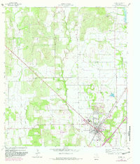
1964 Map of Devine
USGS Topo · Published 1982About this map
Devine serves as the focal point of this Medina County landscape, positioned where the Missouri Pacific railroad cuts through the terrain. The town shows significant mid-century infrastructure, including the Devine Municipal Airport and a centralized education hub featuring the High Sch and Jr High Sch. Water management is a defining characteristic of the surrounding countryside, with the Chacon Reservoir and Jungman Lake situated amidst a network of waterways like San Francisco Perez Creek and Burnt Boot Creek.
Find a feature on this map
20 named features on this map. Tap any name to fly to it.
Don’t see what you’re looking for? This feature index may not catch every label — zoom into the map to look around manually.
Map Details
Editions of this 1964 Devine Map
2 editions found
Other maps of this area

1942 · Natalia
USGS Topo · 1:62,500

1954 · San Antonio
USGS Topo · 1:250,000

1956 · New Fountain
USGS Topo · 1:62,500

1957 · San Antonio
USGS Topo · 1:250,000

1958 · La Coste
USGS Topo · 1:24,000

1964 · Ghost Hill
USGS Topo · 1:24,000

1964 · Castroville
USGS Topo · 1:24,000

1964 · Devine
USGS Topo · 1:24,000
1964 · Moore
USGS Topo · 1:24,000
1964 · Lytle
USGS Topo · 1:24,000