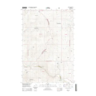
2014 Map of Dewey
USGS Topo · Published 2014About this map
The Dewey settlement and its surrounding alpine terrain are the focal points of this 2014 survey along the boundary of the Silver Bow Co Beaverhead Co line. Resting near the banks of the Big Hole River, the area is defined by the significant intersection of the Beaverhead National Forest and the Deerlodge National Forest. This montane landscape is characterized by high ridges and steep gulches, including Fleecer Ridge and the prominent Mt Fleecer. Evidence of local history and resource management is found in the Dewey Cem and named drainages such as Sawmill Gulch and Limekiln Gulch. The map reveals a network of forest access via Jerry Creek Rd and Fleecer Mtn Rd, providing a detailed look at the interface between the river valley and the high-elevation backcountry of southwest Montana.
Find a feature on this map
54 named features on this map. Tap any name to fly to it.
Don’t see what you’re looking for? This feature index may not catch every label — zoom into the map to look around manually.
Map Details
Editions of this 2014 Dewey Map
This is the sole edition of this map. No revisions or reprints were ever made.
Other maps of this area

1893 · Dillon
USGS Topo · 1:250,000

1955 · Dillon
USGS Topo · 1:250,000

1957 · Dillon
USGS Topo · 1:250,000

1958 · Dillon
USGS Topo · 1:250,000

1958 · Vipond Park
USGS Topo · 1:62,500

1961 · Melrose
USGS Topo · 1:24,000
1961 · Burnt Mountain
USGS Topo · 1:24,000
1961 · Dickie Peak
USGS Topo · 1:24,000

1961 · Butte South
USGS Topo · 1:62,500

1961 · Dewey
USGS Topo · 1:24,000