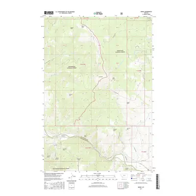
2017 Map of Dewey
USGS Topo · Published 2017About this map
Dewey sits at the southern edge of the Highland Mountains, where the high ridges of the Beaverhead National Forest and Deerlodge National Forest meet. The settlement is positioned near the winding path of the Big Hole River, which forms a portion of the boundary between Silver Bow and Beaverhead counties. The topography is defined by massive landforms like Mt Fleecer and Hogback Ridge, with the higher elevations giving way to numerous drainages such as Nez Perce Gulch and Charcoal Gulch.
Find a feature on this map
59 named features on this map. Tap any name to fly to it.
Don’t see what you’re looking for? This feature index may not catch every label — zoom into the map to look around manually.
Map Details
Editions of this 2017 Dewey Map
This is the sole edition of this map. No revisions or reprints were ever made.
Other maps of this area

1893 · Dillon
USGS Topo · 1:250,000

1955 · Dillon
USGS Topo · 1:250,000

1957 · Dillon
USGS Topo · 1:250,000

1958 · Dillon
USGS Topo · 1:250,000

1958 · Vipond Park
USGS Topo · 1:62,500

1961 · Melrose
USGS Topo · 1:24,000
1961 · Burnt Mountain
USGS Topo · 1:24,000
1961 · Dickie Peak
USGS Topo · 1:24,000

1961 · Butte South
USGS Topo · 1:62,500

1961 · Dewey
USGS Topo · 1:24,000