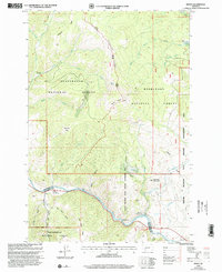
1997 Map of Dewey
USGS Topo · Published 2002About this map
The Big Hole River winds through this southwestern Montana landscape, serving as a vital corridor between the Beaverhead National Forest and Deerlodge National Forest. The settlement of Dewey sits along the river's northern bank, accompanied by the Dewey Cem, while the Divide Sch is located further southeast near the community of Buxton. This area reflects a long history of water management and resource extraction, evidenced by the Aqueduct, the Big Hole Dam, and the Big Hole Pumping Station.
Find a feature on this map
44 named features on this map. Tap any name to fly to it.
Don’t see what you’re looking for? This feature index may not catch every label — zoom into the map to look around manually.
Map Details
Editions of this 1997 Dewey Map
This is the sole edition of this map. No revisions or reprints were ever made.
Other maps of this area

1893 · Dillon
USGS Topo · 1:250,000

1955 · Dillon
USGS Topo · 1:250,000

1957 · Dillon
USGS Topo · 1:250,000

1958 · Dillon
USGS Topo · 1:250,000

1958 · Vipond Park
USGS Topo · 1:62,500

1961 · Melrose
USGS Topo · 1:24,000
1961 · Burnt Mountain
USGS Topo · 1:24,000
1961 · Dickie Peak
USGS Topo · 1:24,000

1961 · Butte South
USGS Topo · 1:62,500

1961 · Dewey
USGS Topo · 1:24,000