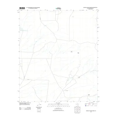
2013 Map of Diablo Canyon West
USGS Topo · Published 2013About this map
Wilkey Ranch stands as a primary landmark in this arid stretch of Hudspeth County, where life and activity revolve around essential water catchments and relief-carved drainage systems. The landscape is defined by the stark topography of Smith Mesa and the complex network of arroyos including Pear Canyon, Flat Canyon, and the prominent Diablo Canyon. Local land management and ranching operations are evident through the infrastructure of numerous tanks and basins such as Prince Albert Tank, Camp Rice Tank, and the Soil Conservation Service Site 1 Reservoir. Natural water sources like Thaxton Spring and Milner Lake further emphasize the critical nature of water in this West Texas environment. Remote thoroughfares like Wilkey Rd and Mosley Rd provide the necessary connections between these isolated ranching outposts and the surrounding rugged terrain.
Find a feature on this map
14 named features on this map. Tap any name to fly to it.
Don’t see what you’re looking for? This feature index may not catch every label — zoom into the map to look around manually.
Map Details
Editions of this 2013 Diablo Canyon West Map
This is the sole edition of this map. No revisions or reprints were ever made.
Other maps of this area

1894 · Fort Hancock
USGS Topo · 1:125,000

1903 · Cerro Alto
USGS Topo · 1:125,000

1942 · Borrego
USGS Topo · 1:62,500

1943 · Tepee Butte
USGS Topo · 1:62,500

1943 · Finlay Mountains
USGS Topo · 1:62,500

1943 · Fort Hancock
USGS Topo · 1:62,500

1954 · Van Horn
USGS Topo · 1:250,000

1958 · Van Horn
USGS Topo · 1:250,000
1972 · Campo Grande Mountain
USGS Topo · 1:24,000
1972 · Small
USGS Topo · 1:24,000