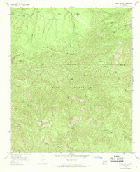
1965 Map of Diablo Range
USGS Topo · Published 1969About this map
The Diablo Range dominates this mid-1960s topographical study, marking a landscape defined by sharp elevation changes and high-altitude parks. Within the Gila National Forest and the more restrictive Gila Wilderness, the terrain is carved by a dense network of drainages including Mogollon Creek and Turkey Creek. The presence of landmarks like White Pinnacle and Mc Kenna Park suggests a region where natural features served as primary navigational waypoints for those traversing the extensive Pack Trail system.
Find a feature on this map
27 named features on this map. Tap any name to fly to it.
Don’t see what you’re looking for? This feature index may not catch every label — zoom into the map to look around manually.
Map Details
Editions of this 1965 Diablo Range Map
2 editions found
Other maps of this area

1910 · Mogollon
USGS Topo · 1:125,000

1911 · Alum Mountain
USGS Topo · 1:125,000

1912 · Mogollon
USGS Topo · 1:125,000

1913 · Alum Mountain
USGS Topo · 1:125,000

1954 · Clifton
USGS Topo · 1:250,000

1957 · Clifton
USGS Topo · 1:250,000

1958 · Clifton
USGS Topo · 1:250,000

1962 · Clifton
USGS Topo · 1:250,000
1965 · Canteen Canyon
USGS Topo · 1:24,000
1965 · Mogollon Baldy Peak
USGS Topo · 1:24,000