
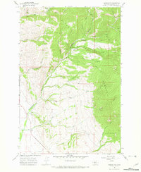
1966 Map of Diamond City
USGS Topo · Published 1970About this map
Diamond City (Site) serves as the focal point of this mid-century topographic record of the Big Belt Mountains, situated within the Helena National Forest. The landscape is deeply incised by a network of drainages famously tied to the region's mining heritage, most notably Confederate Gulch and White Gulch. While the city itself is noted as a site, the map preserves the locations of early local infrastructure such as the Johnson Sch and a small Cem near the creek. Evidence of resource extraction is scattered across the slopes, from the Miller Mine in the north to various unnamed Mines and a Prospect along Boulder Creek. The terrain is navigated by a system of Jeep Trails and Pack Trails, illustrating how this part of Broadwater County was accessed for both industry and forest management before modern road development reached deeper into the gulches.
Find a feature on this map
37 named features on this map. Tap any name to fly to it.
Don’t see what you’re looking for? This feature index may not catch every label — zoom into the map to look around manually.
Map Details
Editions of this 1966 Diamond City Map
2 editions found
Other maps of this area

1886 · Fort Logan
USGS Topo · 1:250,000

1948 · White Sulphur Springs
USGS Topo · 1:250,000

1950 · Canyon Ferry
USGS Topo · 1:62,500

1950 · Townsend
USGS Topo · 1:62,500

1950 · Duck Creek Pass
USGS Topo · 1:62,500

1958 · White Sulphur Springs
USGS Topo · 1:250,000

1961 · White Sulphur Springs
USGS Topo · 1:250,000

1965 · White Sulphur Springs
USGS Topo · 1:250,000

1966 · Boulder Baldy
USGS Topo · 1:24,000

1966 · Whites City
USGS Topo · 1:24,000