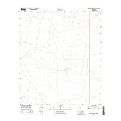
2016 Map of Diamond Y Spring NW
USGS Topo · Published 2016About this map
Monument Springs and Bonebrake Spring serve as the primary landmarks in this arid stretch of Pecos County, signaling the critical importance of water sources in the West Texas landscape. The terrain is defined by the winding course of Courtney Cr, which traverses the central and eastern portions of the map. This 2016 survey illustrates the modern division of land in this region, where large parcels and ranches are accessed by a sparse network of roads such as Gamboa Rd and Trophy Rd. In the northeastern corner, Fm 1450 provides a paved connection through the territory. The map effectively captures a landscape where the natural hydrography, though limited, remains the focal point for settlement and land management in the High Plains.
Find a feature on this map
6 named features on this map. Tap any name to fly to it.
Don’t see what you’re looking for? This feature index may not catch every label — zoom into the map to look around manually.
Map Details
Editions of this 2016 Diamond Y Spring NW Map
This is the sole edition of this map. No revisions or reprints were ever made.
Other maps of this area

1931 · Barstow
USGS Topo · 1:125,000

1954 · Pecos
USGS Topo · 1:250,000

1957 · Pecos
USGS Topo · 1:250,000

1963 · Rio Pecos Ranch
USGS Topo · 1:24,000

1969 · Grandfalls
USGS Topo · 1:24,000
1974 · Diamond Y Spring NE
USGS Topo · 1:24,000
1974 · Coyanosa
USGS Topo · 1:24,000
1974 · Diamond Y Spring SE
USGS Topo · 1:24,000
1974 · Diamond Y Spring
USGS Topo · 1:24,000
1974 · Diamond Y Spring NW
USGS Topo · 1:24,000