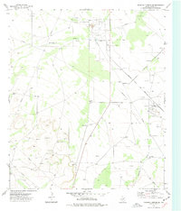
1974 Map of Diamond Y Spring SE
USGS Topo · Published 1977About this map
The Chicklynn Oil Field defines much of the industrial character in this Pecos County landscape, with a network of drill holes and a Pipeline system supporting the mid-1970s energy economy. This arid terrain is marked by essential water features like Diamond Y Draw and Comanche Creek, which influenced the location of ranching operations such as San Pedro Ranch. The eastern portion of the sheet is bisected by the Atchison Topeka and Santa Fe railroad, which provided the vital transportation link for the region's extractive industries, including several instances of a mine and numerous gravel extractions like the Devlin Gravel Pit. Isolated settlements and markers like Bennett and the Sulphur Plant indicate a specialized landscape where natural resources dictated human activity and infrastructure.
Find a feature on this map
13 named features on this map. Tap any name to fly to it.
Don’t see what you’re looking for? This feature index may not catch every label — zoom into the map to look around manually.
Map Details
Editions of this 1974 Diamond Y Spring SE Map
This is the sole edition of this map. No revisions or reprints were ever made.
Other maps of this area

1921 · Fort Stockton
USGS Topo · 1:62,500

1923 · Fort Stockton
USGS Topo · 1:62,500

1928 · Comanche Spring
USGS Topo · 1:125,000

1954 · Pecos
USGS Topo · 1:250,000

1954 · Fort Stockton
USGS Topo · 1:250,000

1957 · Pecos
USGS Topo · 1:250,000

1958 · Fort Stockton
USGS Topo · 1:250,000

1970 · Fort Stockton West
USGS Topo · 1:24,000

1970 · East Mesa
USGS Topo · 1:24,000
1970 · Fort Stockton East
USGS Topo · 1:24,000