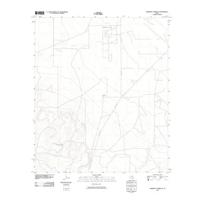
2010 Map of Diamond Y Spring SE
USGS Topo · Published 2010About this map
Chicklynn Oil Field defines the northern reaches of this Pecos County landscape, where industrial extraction and ranching infrastructure converge. The terrain is characterized by a network of utility roads and property boundaries, including the prominent San Pedro Ranch located centrally between the drainages of Leon Creek and Comanche Creek. This 2010 survey by the U.S. Geological Survey illustrates the modern configuration of rural Texas, where high-relief topography in the southwest transitions into a broader basin organized around ranching interests. Transportation through this arid region is anchored by Ranch Rd 1053 and Buenavista Rd, which connect the scattered homesteads and mineral operations to the larger regional network.
Find a feature on this map
6 named features on this map. Tap any name to fly to it.
Don’t see what you’re looking for? This feature index may not catch every label — zoom into the map to look around manually.
Map Details
Editions of this 2010 Diamond Y Spring SE Map
This is the sole edition of this map. No revisions or reprints were ever made.
Other maps of this area

1921 · Fort Stockton
USGS Topo · 1:62,500

1923 · Fort Stockton
USGS Topo · 1:62,500

1928 · Comanche Spring
USGS Topo · 1:125,000

1954 · Pecos
USGS Topo · 1:250,000

1954 · Fort Stockton
USGS Topo · 1:250,000

1957 · Pecos
USGS Topo · 1:250,000

1958 · Fort Stockton
USGS Topo · 1:250,000

1970 · Fort Stockton West
USGS Topo · 1:24,000

1970 · East Mesa
USGS Topo · 1:24,000
1970 · Fort Stockton East
USGS Topo · 1:24,000