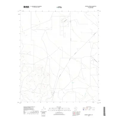
2019 Map of Diamond Y Spring SE
USGS Topo · Published 2019About this map
San Simon Springs anchors this high-desert landscape in Pecos County, where ephemeral watercourses define the drainage patterns of the Trans-Pecos region. The network of dry draws and seasonal creeks, including Leon Cr and Diamond Y Draw, illustrates the precarious water management of West Texas ranching country. Sparse infrastructure connects the landscape, primarily through Ranch Rd 1053 and Buena Vista Rd, reflecting a region dominated by large landholdings rather than dense settlements. In the southeast, the terrain shifts toward Comanche Cr, while the inclusion of Texas Gulf Plant Rd points to the industrial footprint of the energy and mineral extraction sectors that have long shaped the local economy alongside traditional agriculture.
Find a feature on this map
7 named features on this map. Tap any name to fly to it.
Don’t see what you’re looking for? This feature index may not catch every label — zoom into the map to look around manually.
Map Details
Editions of this 2019 Diamond Y Spring SE Map
This is the sole edition of this map. No revisions or reprints were ever made.
Other maps of this area

1921 · Fort Stockton
USGS Topo · 1:62,500

1923 · Fort Stockton
USGS Topo · 1:62,500

1928 · Comanche Spring
USGS Topo · 1:125,000

1954 · Pecos
USGS Topo · 1:250,000

1954 · Fort Stockton
USGS Topo · 1:250,000

1957 · Pecos
USGS Topo · 1:250,000

1958 · Fort Stockton
USGS Topo · 1:250,000

1970 · Fort Stockton West
USGS Topo · 1:24,000

1970 · East Mesa
USGS Topo · 1:24,000
1970 · Fort Stockton East
USGS Topo · 1:24,000