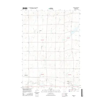
2015 Map of Dickens
USGS Topo · Published 2015About this map
Dickens and the outskirts of Spencer anchor this portion of Clay County, Iowa, where the landscape is defined by the winding paths of the Little Sioux River and several significant tributaries. This survey captures a modern agricultural grid punctuated by glacial features like the Dan Green Slough and the Lost Island Outlet in the southeast. The drainage patterns of Big Muddy Cr and Little Muddy Cr dictate the layout of rural roads and the location of small settlements like Langdon. Local history is preserved at sites such as Fairview Cem and Dickens Cem, which serve as quiet landmarks among the expansive fields. The map provides a detailed view of the regional infrastructure, including the junction of Co Hwy M54 and Co Rd B24, illustrating the intersection of natural waterways and human development.
Find a feature on this map
39 named features on this map. Tap any name to fly to it.
Don’t see what you’re looking for? This feature index may not catch every label — zoom into the map to look around manually.
Map Details
Editions of this 2015 Dickens Map
This is the sole edition of this map. No revisions or reprints were ever made.
Other maps of this area

1954 · Fairmont
USGS Topo · 1:250,000

1958 · Fairmont
USGS Topo · 1:250,000

1966 · Spencer
USGS Topo · 1:24,000

1966 · Gillett Grove
USGS Topo · 1:24,000

1966 · Greenville
USGS Topo · 1:24,000

1966 · Dickens
USGS Topo · 1:24,000

1970 · Milford
USGS Topo · 1:24,000

1970 · Spirit Lake SE
USGS Topo · 1:24,000

1972 · Terril
USGS Topo · 1:24,000
1972 · Silver Lake
USGS Topo · 1:24,000