
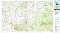
1985 Map of Dickens
USGS Topo · Published 1985About this map
Roaring Springs and the surrounding ranching country of West Texas are captured here during a period of steady land use in the mid-1980s. The map illustrates a complex network of canyons and breaks, notably the Croton Breaks and Davidson Canyon, where the landscape is defined by the headwaters of the Wichita River and the Tongue River. The presence of the Fort Worth and Denver Railroad in the northwest corner highlights the historical importance of rail transport for moving cattle and goods from the region.
Find a feature on this map
50 named features on this map. Tap any name to fly to it.
Don’t see what you’re looking for? This feature index may not catch every label — zoom into the map to look around manually.
Map Details
Editions of this 1985 Dickens Map
2 editions found
Other maps of this area

1932 · Vivian
USGS Topo · 1:62,500

1954 · Lubbock
USGS Topo · 1:250,000

1954 · Plainview
USGS Topo · 1:250,000

1954 · Wichita Falls
USGS Topo · 1:250,000

1955 · Lawton
USGS Topo · 1:250,000

1958 · Wichita Falls
USGS Topo · 1:250,000

1958 · Plainview
USGS Topo · 1:250,000

1958 · Pursley House
USGS Topo · 1:24,000

1958 · Southerland Canyon
USGS Topo · 1:24,000

1959 · Gilpin
USGS Topo · 1:24,000