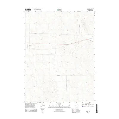
2014 Map of Dickens
USGS Topo · Published 2014About this map
Dickens sits at the crossroads of Ne-23 and N Dickens Rd, serving as the primary hub for this section of Lincoln County. The settlement is anchored by a local Po and the nearby Dickens Cem, reflecting the small-town infrastructure typical of the Nebraska high plains. The surrounding landscape is defined by a grid of rural routes such as Nelson Rd and W Jenkins Rd, which navigate the undulating topography of the region. To the northeast, the terrain is cut by the drainage of Medicine Cr, providing a rare hydrological feature in an otherwise dry, upland environment. This survey captures the sparse but organized settlement pattern of the early twenty-first century, where large-scale agriculture and cattle ranching are supported by a thin network of improved and unimproved roads like Game Trail Rd.
Find a feature on this map
15 named features on this map. Tap any name to fly to it.
Don’t see what you’re looking for? This feature index may not catch every label — zoom into the map to look around manually.
Map Details
Editions of this 2014 Dickens Map
This is the sole edition of this map. No revisions or reprints were ever made.
Other maps of this area

1954 · McCook
USGS Topo · 1:250,000

1956 · White NE
USGS Topo · 1:24,000

1956 · Dickens
USGS Topo · 1:24,000

1956 · Somerset
USGS Topo · 1:24,000

1957 · McCook
USGS Topo · 1:250,000

1958 · McCook
USGS Topo · 1:250,000
1970 · Dickens NE
USGS Topo · 1:24,000
1970 · Dickens NW
USGS Topo · 1:24,000

1973 · Suttlers Canyon East
USGS Topo · 1:24,000

1973 · Suttlers Canyon West
USGS Topo · 1:24,000