
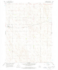
1956 Map of Dickens
USGS Topo · Published 1957About this map
Dickens serves as the primary hub in this Nebraska landscape, situated along the Chicago Burlington and Quincy railroad line. The settlement pattern in the mid-1950s reflects a rural economy deeply tied to the rail corridor and the seasonal flow of Medicine Cr in the northeast corner of the quadrangle. Local landmarks like the Dickens Cem provide valuable points of reference for genealogists tracing family roots in this corner of Lincoln County. Surveyed as part of a Missouri River Basin development program, the topography reveals the transition between distinct survey areas including Kem, Somerset, and Willow.
Find a feature on this map
9 named features on this map. Tap any name to fly to it.
Don’t see what you’re looking for? This feature index may not catch every label — zoom into the map to look around manually.
Map Details
Editions of this 1956 Dickens Map
2 editions found
Other maps of this area

1954 · McCook
USGS Topo · 1:250,000

1956 · White NE
USGS Topo · 1:24,000

1956 · Somerset
USGS Topo · 1:24,000

1957 · McCook
USGS Topo · 1:250,000

1958 · McCook
USGS Topo · 1:250,000
1970 · Dickens NE
USGS Topo · 1:24,000
1970 · Dickens NW
USGS Topo · 1:24,000

1973 · Suttlers Canyon East
USGS Topo · 1:24,000

1973 · Suttlers Canyon West
USGS Topo · 1:24,000
1973 · Wallace NE
USGS Topo · 1:24,000