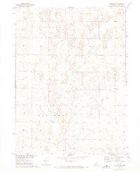
1970 Map of Dickens NW
USGS Topo · Published 1973About this map
Sandhills topography and scattered agricultural features define this rural portion of Lincoln County as it appeared in the early 1970s. The landscape is characterized by a high density of closed-contour depressions and small intermittent ponds, typical of the Nebraska Platte River basin's uplands. Human activity is sparse across the townships of Dickens and Sellers, marked primarily by a lattice of field lines and isolated homesteads like Graves. A prominent industrial feature, a long Pipeline, cuts through the southern sections of the map, providing a sharp contrast to the irregular natural contours. This survey serves as a detailed record of the region’s land use patterns before modern pivots changed the face of High Plains agriculture.
Find a feature on this map
5 named features on this map. Tap any name to fly to it.
Don’t see what you’re looking for? This feature index may not catch every label — zoom into the map to look around manually.
Map Details
Editions of this 1970 Dickens NW Map
This is the sole edition of this map. No revisions or reprints were ever made.
Other maps of this area

1898 · Paxton
USGS Topo · 1:125,000

1899 · North Platte
USGS Topo · 1:125,000

1901 · Paxton
USGS Topo · 1:125,000

1902 · North Platte
USGS Topo · 1:125,000

1954 · McCook
USGS Topo · 1:250,000

1954 · North Platte
USGS Topo · 1:250,000

1956 · North Platte
USGS Topo · 1:250,000

1956 · Dickens
USGS Topo · 1:24,000

1956 · Somerset
USGS Topo · 1:24,000

1957 · North Platte
USGS Topo · 1:250,000