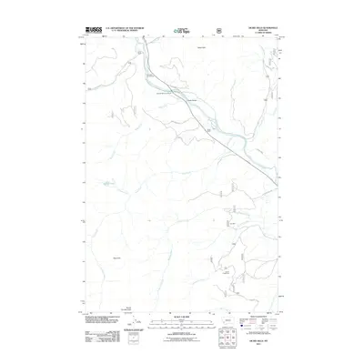
2011 Map of Dickie Hills
USGS Topo · Published 2011About this map
The Big Hole River winds through this mountainous terrain in Silver Bow County, serving as a central artery for both recreation and local industry. The landscape is defined by the Dickie Hills and the prominent Round Top Mountain to the south, with various drainages such as Teddy Creek and Alder Creek feeding the river system. Longstanding land use is evident in the presence of the Davis Ranch and Glaus Ranch, while the area's mining history is anchored by the Star Mine and Bryant Creek Mine. Infrastructure like the Dickie Bridge and roads such as Alder Creek Rd facilitate access to the back country and specialized sites like Foolhen Lake. For those interested in the outdoor character of the region, the East Bank Campground and Dickie Bridge Campground highlight the area's role as a destination for river-based activity near Heart Park.
Find a feature on this map
28 named features on this map. Tap any name to fly to it.
Don’t see what you’re looking for? This feature index may not catch every label — zoom into the map to look around manually.
Map Details
Editions of this 2011 Dickie Hills Map
This is the sole edition of this map. No revisions or reprints were ever made.
Other maps of this area

1893 · Dillon
USGS Topo · 1:250,000

1955 · Dillon
USGS Topo · 1:250,000

1957 · Dillon
USGS Topo · 1:250,000

1958 · Dillon
USGS Topo · 1:250,000

1958 · Vipond Park
USGS Topo · 1:62,500
1961 · Dickie Peak
USGS Topo · 1:24,000

1961 · Wise River
USGS Topo · 1:24,000

1962 · Dillon
USGS Topo · 1:250,000

1962 · Lincoln Gulch
USGS Topo · 1:24,000

1962 · Lower Seymour Lake
USGS Topo · 1:24,000