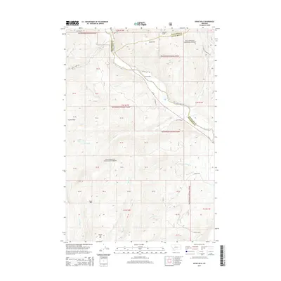
2014 Map of Dickie Hills
USGS Topo · Published 2014About this map
Dickie Hills and the winding course of the Big Hole River define this corner of the Beaverhead National Forest at the triple junction of Silver Bow, Deer Lodge, and Beaverhead counties. This terrain is marked by a complex network of drainage creeks including Bryant Cr, Bear Cr, and Johnson Cr, which flow through the high country towards the river. Significant elevation features such as Round Top Mtn and Foolhen Ridge overlook high-altitude water bodies like Foolhen Lake. Small settlements and crossings like Dickie Bridge and Still Gulch provide narrow points of access into the forest, connected by rugged routes such as Bryant Creek Rd and Johnson Creek Rd. The presence of Heart Park suggests established recreational or communal spaces within this mountainous landscape, while the detailed drainage patterns of Harriet Lou Cr and Osborne Cr indicate the importance of water management in this high-altitude environment.
Find a feature on this map
51 named features on this map. Tap any name to fly to it.
Don’t see what you’re looking for? This feature index may not catch every label — zoom into the map to look around manually.
Map Details
Editions of this 2014 Dickie Hills Map
This is the sole edition of this map. No revisions or reprints were ever made.
Other maps of this area

1893 · Dillon
USGS Topo · 1:250,000

1955 · Dillon
USGS Topo · 1:250,000

1957 · Dillon
USGS Topo · 1:250,000

1958 · Dillon
USGS Topo · 1:250,000

1958 · Vipond Park
USGS Topo · 1:62,500
1961 · Dickie Peak
USGS Topo · 1:24,000

1961 · Wise River
USGS Topo · 1:24,000

1962 · Dillon
USGS Topo · 1:250,000

1962 · Lincoln Gulch
USGS Topo · 1:24,000

1962 · Lower Seymour Lake
USGS Topo · 1:24,000