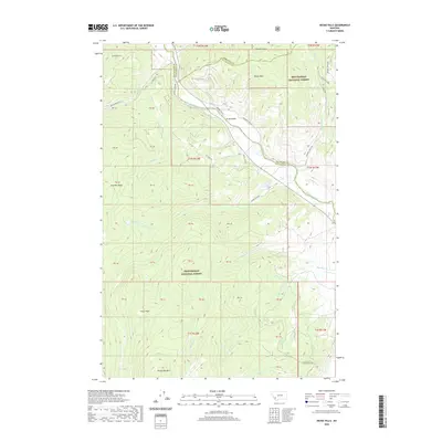
2020 Map of Dickie Hills
USGS Topo · Published 2020About this map
The Big Hole River winds through the eastern portion of this landscape, a vital watercourse marking the border between Silver Bow and Beaverhead counties. This montane region is largely defined by the Beaverhead National Forest, where the topography rises sharply toward Dickie Hills and Round Top Mtn. The map reveals a network of forest access routes like Bryant Creek Rd and Tie Creek Rd that navigate the drainages of Bear Cr and Johnson Gulch.
Find a feature on this map
52 named features on this map. Tap any name to fly to it.
Don’t see what you’re looking for? This feature index may not catch every label — zoom into the map to look around manually.
Map Details
Editions of this 2020 Dickie Hills Map
This is the sole edition of this map. No revisions or reprints were ever made.
Other maps of this area

1893 · Dillon
USGS Topo · 1:250,000

1955 · Dillon
USGS Topo · 1:250,000

1957 · Dillon
USGS Topo · 1:250,000

1958 · Dillon
USGS Topo · 1:250,000

1958 · Vipond Park
USGS Topo · 1:62,500
1961 · Dickie Peak
USGS Topo · 1:24,000

1961 · Wise River
USGS Topo · 1:24,000

1962 · Dillon
USGS Topo · 1:250,000

1962 · Lincoln Gulch
USGS Topo · 1:24,000

1962 · Lower Seymour Lake
USGS Topo · 1:24,000