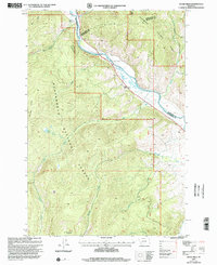
1997 Map of Dickie Hills
USGS Topo · Published 2002About this map
Dickie Hills and the winding Big Hole River define this high-altitude landscape within the Beaverhead National Forest during the late 1990s. The map illustrates a remote terrain where resource extraction and recreation meet, shown through the presence of a Gravel Pit, a Mine near Meadow Creek, and the Dickie Bridge Campground. Transportation is focused along the Pioneer Mountains Scenic Byway, which follows the river valley and provides access to local landholdings like the Dace Ranch and Glaus Ranch. High-country water features, including Foolhen Lake and numerous drainages like Alder Creek and Osborne Creek, underscore the area's role as a vital watershed. The map's detailed boundaries also track the junction of Beaverhead, Silver Bow, and Deer Lodge counties as they converge near the river's northern bend.
Find a feature on this map
28 named features on this map. Tap any name to fly to it.
Don’t see what you’re looking for? This feature index may not catch every label — zoom into the map to look around manually.
Map Details
Editions of this 1997 Dickie Hills Map
This is the sole edition of this map. No revisions or reprints were ever made.
Other maps of this area

1893 · Dillon
USGS Topo · 1:250,000

1955 · Dillon
USGS Topo · 1:250,000

1957 · Dillon
USGS Topo · 1:250,000

1958 · Dillon
USGS Topo · 1:250,000

1958 · Vipond Park
USGS Topo · 1:62,500
1961 · Dickie Peak
USGS Topo · 1:24,000

1961 · Wise River
USGS Topo · 1:24,000

1962 · Dillon
USGS Topo · 1:250,000

1962 · Lincoln Gulch
USGS Topo · 1:24,000

1962 · Lower Seymour Lake
USGS Topo · 1:24,000