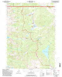
1991 Map of Dickinson Park
USGS Topo · Published 1997About this map
Wind River Indian Reservation land and the Shoshone National Forest meet in this high-altitude landscape of the Wind River Range. The 1991 revision emphasizes the preservation of the Popo Agie Wilderness, where mechanized travel gives way to the historic Bears Ears Trail and the Panto Park Trail. High-country water sources such as Shoshone Lake and Smith Lake dominate the terrain, which is defined by prominent peaks like Hobbs Peak and Mount Chevo. The small outpost of Dickinson Park serves as a critical access point for this backcountry, marking the edge of the road system near Dickinson Creek. This map documents a region where the geography is shaped by water bodies like Sand Lake and Funnel Lake, and where boundary lines for the Lander Ranger District trace the intersection of federal and tribal lands.
Find a feature on this map
42 named features on this map. Tap any name to fly to it.
Don’t see what you’re looking for? This feature index may not catch every label — zoom into the map to look around manually.
Map Details
Editions of this 1991 Dickinson Park Map
This is the sole edition of this map. No revisions or reprints were ever made.
Other maps of this area

1937 · Moccasin Lake
USGS Topo · 1:48,000

1943 · Moccasin Lake
USGS Topo · 1:62,500

1952 · Wind River
USGS Topo · 1:24,000

1953 · Sweetwater Gap
USGS Topo · 1:24,000

1953 · Cony Mountain
USGS Topo · 1:24,000

1953 · Mount Arter
USGS Topo · 1:24,000

1955 · Lander
USGS Topo · 1:250,000

1958 · Lander
USGS Topo · 1:250,000

1961 · Lander
USGS Topo · 1:250,000
1969 · Temple Peak
USGS Topo · 1:24,000