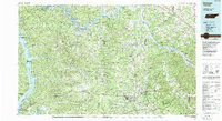
1985 Map of Dickson
USGS Topo · Published 1985About this map
Kentucky Lake and Lake Barkley dominate the northwestern landscape of this mid-1980s Tennessee region, where the Tennessee and Cumberland River systems define the terrain. The area is characterized by a high concentration of protected lands and conservation areas, from the Land Between the Lakes to the expansive Cheatham State Wildlife Management Area. These waters and preserves frame a network of established settlements such as Dickson, Waverly, and Ashland City, all linked by the Seaboard System railroad tracks that cut across the southern and central sections.
Find a feature on this map
82 named features on this map. Tap any name to fly to it.
Don’t see what you’re looking for? This feature index may not catch every label — zoom into the map to look around manually.
Map Details
Editions of this 1985 Dickson Map
This is the sole edition of this map. No revisions or reprints were ever made.
Other maps of this area

1901 · Colombia
USGS Topo · 1:125,000

1903 · Nashville
USGS Topo · 1:125,000

1909 · Franklin
USGS Topo · 1:62,500

1930 · White Bluff
USGS Topo · 1:62,500

1931 · Erin
USGS Topo · 1:62,500

1931 · Ridgetop
USGS Topo · 1:62,500

1932 · Nashville
USGS Topo · 1:62,500

1933 · White Bluff
USGS Topo · 1:62,500

1935 · Ridgetop
USGS Topo · 1:62,500

1936 · Poplar Creek
USGS Topo · 1:24,000